
Long ago, I had maps of various areas of Windemere and a world map. Most importantly, I had one of Elysium, which was very important for one of the series. Well, the folder that they were in got left somewhere and tossed out. I believe I left it at an old friend’s house and we never saw it again. All of my original role-playing character sheets were in there too. They were rather amateur anyway.
So, I don’t use or make maps. I’m too scared I’ll lose them again, but many authors use them to help in fantasy world building. They help readers follow along and get a visual for the world. Maybe someone will draw real maps of Windemere one day, but it won’t be me as you’ll see below.

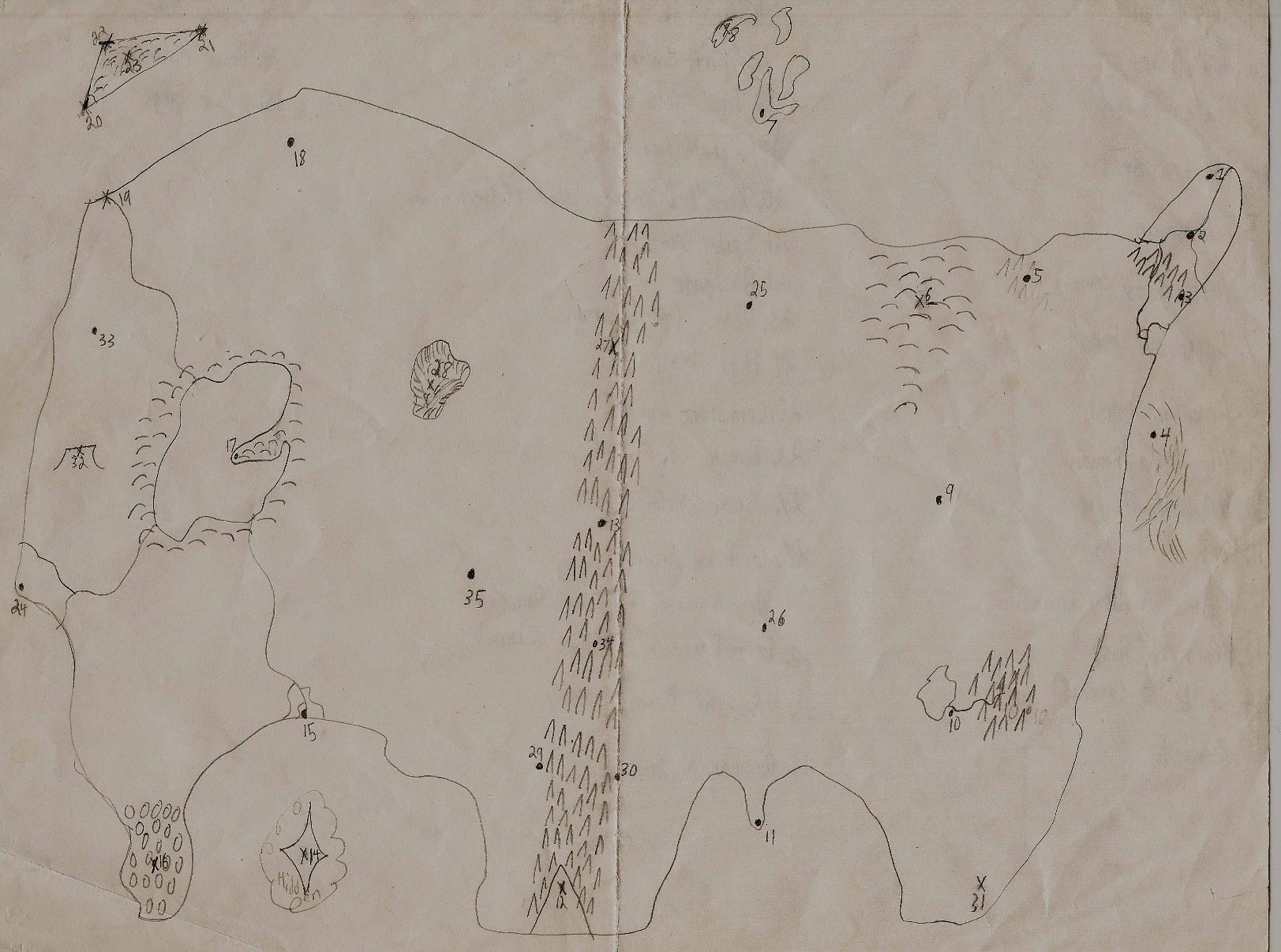
Continent of Ralian
This is the continent where Legends of Windemere takes place. It looks rather empty, but there are three reasons for that. First is that there are a lot of small villages that will pop up when stories need them. Second is that many of the cities are huge and take up a lot of space, so much of the populations of some regions are there. There are many nomadic groups that exist outside of the cities like the gypsies and orcs. Third is that I haven’t created the series that other cities appear in or they haven’t appeared in Legend of Windemere. For example, the city of Fyric, ruins of Gale Hollow, and the Widowhorn aren’t on there since I just finished making them for Curse of the Dark Wind. They’ll be around the ‘T’ in ‘Forest’. This is why the entire region to the East is void of cities. The Yagervan Plains are also a nomadic region with the tribes moving into the Conifer Woods at times. The Tundra and Cold Desert are monster regions with only a few small ports and outposts.
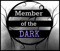
Canst’s Fields
This map is of another continent called Canst’s Fields. Named after the Primordial God of Hope and the Yellow Moon, this western land holds most of the ancient ruins from before the Great Cataclysm. The population is a lot less than Ralian and each town has its own government. It’s a lot of farming villages and merchants with many of the big towns circling around a central business. The map covers the ruins and major areas of this place and was used for the planning of Ruins of the Zodiac Gods. I need to figure out what to call the Zodiac in Windemere at some point. I don’t go here as often as Ralian and Cerascent Islands. It’s very quiet here.
Speaking of Cerascent Islands, I don’t think I’d ever draw that one. It’s a huge archipelago that I’m always adding islands to. It plays a role in a lot of the later books because the Orcs have their central government there and many islands are unique with their own cultures. It is the perfect place for me to use when I need to do something strange with the land or creatures. A lot happens there and I make at least one island for every event. Sin’s first adventure probably puts 5-7 big ones in the area. Reason for the name is that the continent is shaped like a serpent trying to swallow a crescent moon.
Those are the surviving maps of Windemere and my quick thoughts on the use of maps. Not as short and sweet as I expected.


I am such a visually oriented person, I rather like them. maybe when the series is all done, you can have map posters made for your fans 🙂
LikeLike
I’ll just need to find someone who can draw real maps. Posters of these would be a disaster. 🙂
LikeLike
I think these are really neat!! 🙂
LikeLike
Thanks.
LikeLike
Yay!! Love your maps! I’m sorry you lost the others. I love all of the details in the ones in the photos.
I also add to my maps as I go along in my series. Mine aren’t to scale, however.
LikeLike
Thanks. I’ll be adding as I go along and remember. A lot of open space.
LikeLike
Usually I study the map before reading and refer to it frequently when reading fantasy.
LikeLike
I just flip back if need be, but I’m lazy.
LikeLike
Well, they work as a guide for you. That’s what matters. My first map was a sketch on the back of a scrap sheet of paper and it looked similar to what you have. I still have it. The locations on your first map where there are smudges must be tough places to live (okay, that was humor). 🙂
LikeLike
Truly terrible places. Not a decent erase in the place. Be careful buying mechanical pencils in bulk.
LikeLike
Ha ha! I’ll remember that. 😄
LikeLike
I remember my first map fondly. It looked like a fish. A really awful fish … pooping.
Needless to say, it doesn’t look that way now.
LikeLike
My first one was a globe with four blogs in each direction and a collection of small blobs in the middle. Laziest world design ever.
LikeLike
I love these, Charles! I’m a map fiend (my friends buy me illustrated atlases and other maps for Christmas!).
LikeLike
Thanks. Do maps change often enough to get a yearly one?
LikeLike
Not a yearly one so much as a differently styled one. This year was the national geographic illustrated atlas of great civilizations. I am in nerd heaven. I read it when I’m watching TV with Tom! 🙂
LikeLike
Very cool. The ancient world always feels more fascinating than today.
LikeLike
Hardscrabble though it may have been (comparatively), it seems as though they at least “lived” in their world – I think, from our perspective, the uncertainty of their lives made it a bit more interesting, too.
LikeLike
Good point. Gives it a more ‘adventurous’ feel compared to our world.
LikeLike
i loved this, Charles, really brings your world to life. I have loads of similar maps for my own mythology and initially felt the same way you did but came to enjoy this part of the worldbuilding projects. The maps, like all the other projects, soon got very complicated and out of control, far beyond my capabilities as an artist (which are amature at best) and Ilong to be able to afford to commission a cartographer to do them justice. There is something exciting and compelling about a map, and even the most simple sketches give a story and those who enjoy adventuring in your world, a real sense of ownership and understanding. I look forward to your next efforts in this area and hope you find the missing maps. sir. Great post. best wishes from baldy
LikeLike
I admit that I’m not a fan of making maps. I designed these to help with location and distance. The one map I did enjoy making and hoped to keep is the one that I lost. No idea how to rebuild it either.
LikeLike